Drivers of Forest Change in the South
By Susan Minnemeyer
Southern forests are forests of continual change, and because this change is dispersed in time and space, the full extent of change may go unnoticed. A satellite-based study by the Multi-Resolution Land Characteristics Consortium (MRLC), led by the US Geological Survey (USGS), measured change in land cover from 1992 to 2001 and quantified the extent of forest change in the United States during this decade. The Southern Forests for the Future project analyzed this dataset to measure change in each county and state to better understand patterns of forest change. The USGS MRLC data is highlighted in the Southern Forests for the Future map viewer where the data can be explored in the Forest Cover Gain/Loss and Forestry map themes.
A decade of forest change. According to the USGS, total forest cover in the South was estimated at 178.8 million acres in 1992 and 170.3 million acres in 2001. Between 1992 and 2001, 164.7 million acres (89%) of the forests in the South remained unchanged (were forested in both time periods), while 14.1 million acres (8% of 1992 forest cover) of forest cover was lost and 5.4 million acres was newly covered by forest since 1992 (3%), resulting in an overall net loss of 8.7 million acres of forest cover since 1992 (5%).
Some forest cover change was temporary, resulting from harvesting and replanting of forests managed for timber and pulpwood production. Significant areas of forest cover were both converted to agricultural uses, a long term change in forests, or reverted back to forest from farmland. The leading cause of permanent forest change was urbanization. See Table 1 and Figure 1 for more information on the main categories of forest change.
Estimates of forest area in the South. The two main estimates of current forest cover that exist for the South are the USGS’s National Land Cover Dataset (NLCD) which estimates 170 million acres of forest for 2001 and the USDA Forest Service’s Forest Resources of the United States report, which uses Forest Inventory & Analysis (FIA) data to estimate 214 million acres of forest for the South in 2007. There are several reasons these estimates differ, primarily because different criteria are used to identify forest. The NLCD study is based on an analysis of satellite imagery to measure land cover, while the FIA data are based on ground sample plots that look at both tree stocking and land use. Thus, while the NLCD identifies areas covered by sufficient tree density to be considered a forest, the FIA assessment uses different criteria to assess forest land use. For example, land that is temporarily without trees following a timber harvest is considered non-forest by the NLCD dataset but is considered forest land use by the FIA analysis. Forest fragments within the environs of a city are considered urban land use by the FIA and not forest, while these forest fragments are counted as forest by the NLCD. Both estimates are useful lenses for evaluating forest status and condition, as well as evaluating long term dynamics in forest extent and distribution.
Suburban encroachment is a leading cause of permanent forest loss . Suburbanization is the leading cause of forest loss (permanent forest change), with over 1.4 million acres lost to urbanization during the 1990s according to the NLCD dataset. The rapid population growth and expansion of cities in the South is expected to continue this trend. Hotspots of suburban encroachment include the outskirts of major urban areas throughout the South. The county with the greatest amount of forest to urbanization between 1992 and 2001 was Gwinnett County, Georgia outside Atlanta, with a loss of over 25,000 acres. The remainder of the top five counties for forest loss were: Bexar County, Texas (home to San Antonio); Mecklenburg County, North Carolina (Charlotte); Wake County, North Carolina (Raleigh); and Travis County, Texas (Austin). Of the top 20 counties in terms of forest loss to suburban encroachment, seven are in the metropolitan area of Atlanta, Georgia, which is one of the fastest growing metropolitan areas in the United States, according to the US Census.
 Figure 2. Urbanization is a leading cause of deforestation—the permanent loss of forests to another land use—in the South. Counties with the greatest loss of forest due to urbanization were in the fringe of rapidly growing metropolitan areas, including Atlanta, Georgia; Raleigh, Charlotte, and Greensboro, North Carolina; Houston, Dallas, Austin, and San Antonio, Texas; Tampa and Jacksonville, Florida; Louisville, Kentucky; and the northern Virginia suburbs of Washington, DC.
The US Forest Service estimates that suburban encroachment will impact approximately 12 million acres of southern forests between 1992 and 2020 and an additional 19 million acres between 2020 and 2040, for a total of 31 million acres. This Forest Service forecast was based on an assessment of land use, predicting extensive conversion of forests to developed land use, as well as fragmentation of forests by development, in coming years. Because these suburban and urban areas will still retain many small areas of forest cover, this forecast estimates a larger area of forests affected than the MRLC/USGS remote sensing data, which measures exact changes in forest cover rather than changes in dominant land use.
Forestry activity is the leading cause of forest cover change. As the South is the “wood basket” of the nation and a global leader in roundwood and pulpwood production, it should be no surprise that forestry activity is responsible for a majority of the change in forests in the South, appearing as forest loss to grassland/shrub when forests are harvested (60% of all forest cover loss from 1992-2001), and forest gain from grassland/shrub when forests are replanted or naturally regenerate (45% of all forest cover gain).
Additional sources of forest cover gain and loss. Forest cover loss to agriculture and reversion of farmland back to forest are both significant drivers of forest change. Changing crop and timber values largely drive these land dynamics. Gain of forest from agriculture includes both timber plantations as well as natural regeneration of forest on abandoned farm or pastureland. Forest cover loss to barren is the smallest category of forest loss, but is a significant driver of forest loss in some areas, such as eastern Kentucky, where forest loss to mountaintop coal mining is extensive.
Update to be released in 2010. The USGS MRLC is expected to release an updated land cover survey in late 2010 of land cover change between 2001 and 2006. This update will provide further information on the drivers of change that influence patterns of forest cover gain and loss.
Data resources:
Access the full database of forest cover gain and loss statistics by county and state, 1992-2001.
Download maps based on forest cover change statistics.
Sources:
USGS National Landcover Database, 1992-2001 Change (2003). Publication: Fry, J.A., Coan, M.J., Homer, C.G., Meyer, D.K., and Wickham, J.D., 2009, Completion of the National Land Cover Database (NLCD) 1992–2001 Land Cover Change Retrofit product: U.S. Geological Survey Open-File Report 2008–1379, 18 p.
Wear, David N., and John G. Greis, eds. 2002a. Southern Forest Resource Assessment. Gen. Tech. Rep. SRS-53. Asheville, NC: U.S. Department of Agriculture, Forest Service, Southern Research Station.
Additional graphics
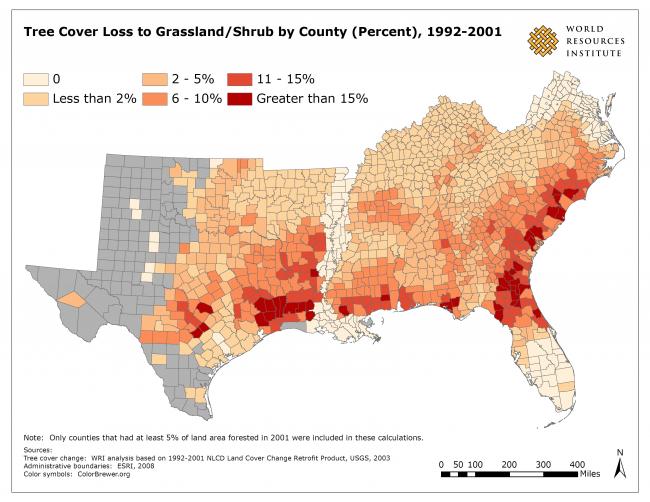
 also had the greatest amount of forest gain. Most of this change took place in rural areas of the South.") Figure 4. Forestry was responsible for the greatest amount of change in forests. Many counties with the greatest loss of forests to grassland/shrub (recently cleared or newly regenerating forests) also had the greatest amount of forest gain. Most of this change took place in rural areas of the South.
Figure 4. Forestry was responsible for the greatest amount of change in forests. Many counties with the greatest loss of forests to grassland/shrub (recently cleared or newly regenerating forests) also had the greatest amount of forest gain. Most of this change took place in rural areas of the South.